This decommissioned ERA site remains active temporarily to support our final migration steps to https://ualberta.scholaris.ca, ERA's new home. All new collections and items, including Spring 2025 theses, are at that site. For assistance, please contact erahelp@ualberta.ca.
- 628 views
- 495 downloads
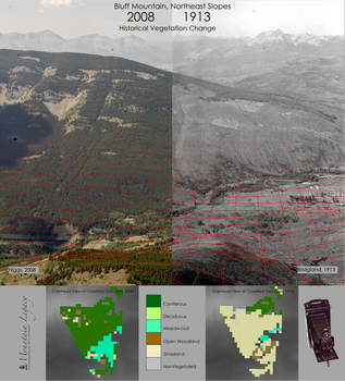
Bluff Mountain, Northeast Slopes. Historic Vegetation Change 1913-2008
-
- Author(s) / Creator(s)
-
The Mountain Legacy Project, the largest repeat photography collection in the world, has more than 6,000 images repeated to date. Previously it was not possible to precisely measure how much and where this change had occurred using oblique angle photographs such as these. I have developed a method to overlay a spatially referenced grid onto the images in order to classify the vegetation. Each red grid cell represents 1 hectare, and geographic coordinates are computed using software from the Swiss Institute of Forestry. Grid cells have been overlaid on the image, but not all grid cells are shown. The two panels at the bottom show an overhead view in ArcGIS of the outputs of this analysis for a single image pair taken in the Crowsnest Pass. The output allows us to see how much has changed, and where the change has occurred. It is clear in the images and output that there is more forest and less grass in 2008 than there was in 1913. In my PhD research, I used this procedure with 124 image pairs to document landscape change over an area 85km x 45km in the southern Alberta Rocky Mountains from 1913-2008. // Program of Study: PhD // Faculty/Department: Renewable Resources // Place of creation: Bluff Mountain, Crowsnest Pass, AB
-
- Date created
- 2016-01-01
-
- Type of Item
- Image
-
- License
- Attribution 4.0 International
